 |
Planisfero (Planisphere, or Overview Map) drawn from Grandes Croniques Saint Denis, 1364-1372. Barbiero implied that this drawing depicts Atlantis, then Antarctica. In it he recognized the "dense network of channels similar to that described by Plato.”
Note also that this was the precise orientation of Romanesque and Gothic cathedrals, which almost always had the apse facing east. |
 |
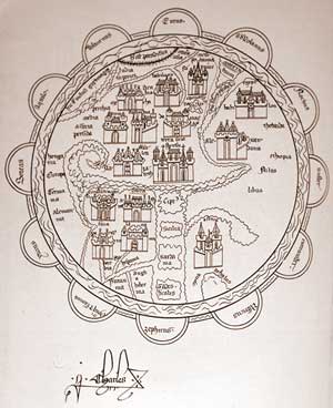
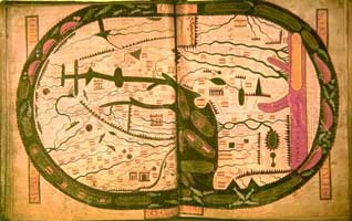
Mappa Mundi (Maps of the Globes) of Hidgen, Ramsey Abbey, 1350
|
 |
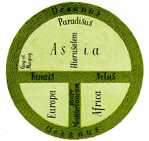
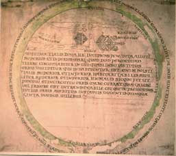
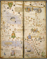
Planisfero (Planisphere, or Overview Map) of Gervase of Tilbury, 1236 This world map is also based on the O-T diagram, but it is peculiar in that the World is depicted as Christ's body, with his head (top) to the East, hands (right and left) at North and South and feet to the West (bottom). We see depicted the most important places in the world (real and mythological): The Earthly Paradise with its four rivers, Mount Ararat with Noah's Ark, the Ganges, the mountains of China, the land of Persia, Egypt and the Nile crocodiles, France including Paris, England and Scotland, Rome, Venice, etc. This map does not reflect real geographical knowledge, but represents the idealized world, according to philosophical and religious principles. The original was destroyed during World War II and now there are only a few copies such as this photograph and from later periods. |
 |
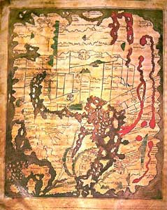
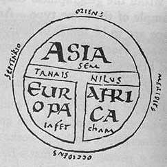
In this map the O-T diagram is less evident and the Mediterranean area begins to be represented more accurately. Again, however, predominance in the depiction is given to biblical stories. Two mythical islands are located off the Atlantic Ocean, Gibraltar as well as the mythical Satanaxium Antilia, the island of demons. At right, the map its pattern is rotated 90 ° so as to bring North to the top. In this map also Barbiero supposed a representation of Atlantis 10,000 years ago.
|
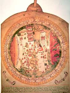 |
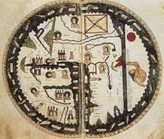
Mappamondo (Map of the Globe), Giovanni Leardo, 1448 A series of symbolic representations of the world appear, linked to medieval conceptions. This map (of which there are two other variants) has some modern features, such as the Mediterranean and Eastern Europe derived from pilot books (nautical maps). Some names are derived from Ptolemy's Geography of Asia and in noteworthy names one sees the influence of Marco Polo. Around the [margins of the] world there is a calendar of years 1448-1494, with ability to calculate the day of Easter. Jerusalem continues to be positioned in the center of the world; at north and south we see two areas colored in red and defined uninhabitable because too cold and too hot, respectively. This map also depicted Atlantis, in this case during the Pleistocene, according to Barbiero |
 |
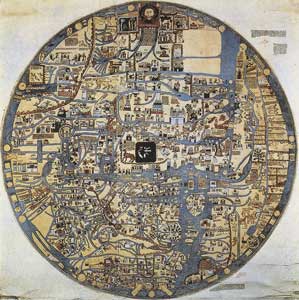
Anglo-Saxon world map (or cottonii), About 1025-1050 Rather than predominantly religious symbolism this globe presents the great civilizations of history: Babylon, Media, Macedonia and Rome. The coasts of England (bottom left), Denmark, the Peloponnese, France and Spain are represented more realistically than on other maps of the time. It contains information of an encyclopedic nature, classical and biblical. The map shows the migration of Jews and cites the City of Bethlehem. This is not a typical Garden of Eden; Gog and Magog are confined behind a wall in the north-east Asia. Griffins, men drawn with dog's heads and a lion drawn in Africa are visible. |
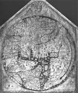 |
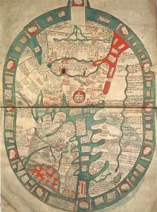
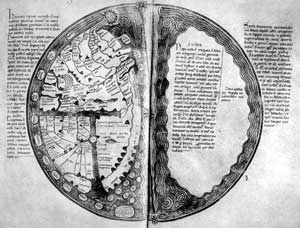
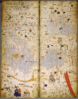
Mappamondo (Map of the Globe) of Hereford, Richard de Bello, 1290 According to Barbiero "the correspondence with the profile of Antarctica Pleistocene is extraordinary. Note Ross Bay at the top right, McKenzie Bay to the left, both with their characteristic profile." This is the largest surviving medieval map of the world, which according to history scholars represents the finest "classical" tradition of such maps. Above you can view the Last Judgment, with Madonna praying for mankind. At the center as always lay Jerusalem, topped by an image of the crucifixion. The names of sites evoke the four empires of human history, the travels of the apostles and routes of pilgrimage, but also mythological stories like the Golden Fleece. Alexandria with its lighthouse, the delta of the Nile with the Pyramids, the Red Sea, and India with the river Ganges, plus the usual earthly paradise at the top (to the East), are shown and specifically named. The images of England and Wales contain representations of Lincoln Cathedral and Welsh castles only recently constructed at the time of Edward I. Also represented are contemporary trade routes with a mixture of sacred and secular meanings. |
Barbiero included reproductions of other maps in the book, all identified with the mythical Atlantis, in all cases without any basis or proof of these statements. The only "science" used by the author is to note the similarity of these images. But since these planispheres are still nothing like Antarctica today, he states that they represent the Pleistocene Antarctic/Atlantis of hundreds of thousands of years ago. According to Barbiero "all medieval planispheres are simply more or less stylized reproductions and adaptations of ancient maps of Antarctica".
But what Barbiero did not see is that many of these medieval maps clearly represented, in the southern hemisphere, the mythical Terra Australis, with a great sea that [encircles and] separates the then-known world (Europe, Asia, Africa).
 .
. 
Although all these documents are derived from Beatus, they clearly show the region of the "Antipodes". The extreme southern hemisphere in these maps is to the right. Some are clearly drawn with a character that appears with his feet hanging over his head (an antipode).
Barbiero’s theory that all medieval planispheres represent an ancient depiction of Antarctica is not possible if they contain within another representation of Antarctica itself. These medieval world maps were based on faith, on sacred texts and on mythological stories, but not on phantom maps of Atlantis, preserved by unknown methods for more than 10,000 years and ending up in the hands of monks in Europe. Of what material would such maps be made to last? And if those ancient Atlantis maps had survived through the ages, what became of them?
By the time those documents were designed, and this should shed light on their purpose, there were already more accurate maps that were based on observations, measurements, and travel reports. In the middle of '300 for example (about the time of the planispheres of Saint Denis and Hidgen and before that of Andrea White) arose the wonderful Catalan Atlas. The Mediterranean is beautifully drawn while Asia still has the typical imaginative features of the old T-type globes.
The medieval world maps that we saw above on this page were not made by sailors or cartographers, but almost always by monks in the monasteries for religious and symbolic purposes, not for practical use. They represented a spiritual world, based on Scripture and the teachings of the Church, what was then thought a reality consistent with their faith. Medieval planispheres were not strictly geographical, much less ancient diagrams of Antarctica.
Diego Cuoghi 2002
Postscript 2007:
On August 1, 2006 a beautifully illustrated book by Alessandro Scafi, dedicated to those medieval maps, was published by University Of Chicago Press: "Il paradiso in terra - Mappe del giardino dell'Eden (Heaven on earth - Maps of the garden of Eden)". The scholar discloses that the purpose of such maps, far from “practical" navigation, was the location of sacred places of the Bible. Theologians especially argued that the Garden of Eden had really existed and still was extant at the remote borders of the known world.
"The depiction of paradise came to play an important role in mapping expressing a vision founded on the Bible. The world maps produced in monasteries and cathedrals of Western Europe were not, however, exposition of theology, pastoral documents and statements of devotion, unlike our modern and scientific representations of the Earth, neither were they instruments of religious propaganda or preaching in visual form. They were rather representations of the world according to a particular concept, a concept that took account of the text of Scripture and the teachings of the Christian faith. Assessed according to their criteria, medieval maps of the world were actually less "scientific" than any other document. (...) It is 'important to understand that to Christian scholars of late antiquity and the Middle Ages the Bible provided the key to all forms of knowledge. In the Sacred Scriptures was certainly the spiritual and religious, but also the most authoritative guide on the creation of the world and history of the human race. The Bible might not provide a great deal of geographical information, but it was the key reference in the study of cosmology, philosophy and history" (Alessandro Scafi 2007).
Here is a review article about the Italian version of the book, including some of the beautiful maps, published by La Repubblica: Eden Maps by Alberto Manguel (PDF).
Other Planispheres and Globes >>>
Pages with charts, maps, globes:
CARTOGRAPHIC
IMAGES HOME PAGE
Index
of Cartographic Images illustrating maps from the Ancient Period: 6,200
B.C. to 400 A.D.
Index
of Cartographic Images Illustrating Maps of the Early Medieval Period 400-1300
A.D.
Index
of Cartographic Images Illustrating Maps of the Late Medieval Period 1300
- 1500 A.D.
Slides/Photo
CDs Illustrating Maps from the Renaissance Period 1500 - 1700
JAMES FORD BELL LIBRARY
MAP HISTORY / History
of Cartograph
ODDENS Bookmarks
- The Fascinating World of Maps and Mapping
Marco
Capurro, "MAPPE DI CITTA' ed altre mappe antiche diverse"
An italian page on the myth of "Terra Australis"
Other studies of Diego Cuoghi in www.diegocuoghi.com