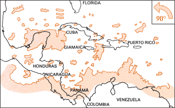
 At
the present day no one believes the existence of the strange inhabitants of
the region of the Baikal Lake that we see in this image, taken from the medieval
"Book of Wonders". So nobody should take as absolutely creditable the cartographic
evidence of the ancient navigation maps dated before 16th century. Maps that
were written up before the discovery of a precise way to calculate the longitude.
Discovery that happened in the 17th century. The geographic maps designed
until that period were based on symbolic systems of representation such as
Jerusalem as the center of the world, inverted north/south orientation, or
different scales for different nations and so on. In many cases these maps
were not drawn on the basis of direct evidence but were copied and modified
from other maps, and were often adapted to suit the needs of nations like
Spain and Portugal, in dispute for the dominion of recently discovered lands.
Added to this fact, it was believed until 1507, that those lands, visited
for the first time by Columbus and then Vespucci, were part of Asia and not
a new continent. Furthermore many maps joined parts of the known Far East
with parts of newly explored lands, and then often added southern mythical
"incognito lands". These additions were made in order to refer to the
ideas of the ancient Greek philosophers (rediscovered in the Renaissance).
At
the present day no one believes the existence of the strange inhabitants of
the region of the Baikal Lake that we see in this image, taken from the medieval
"Book of Wonders". So nobody should take as absolutely creditable the cartographic
evidence of the ancient navigation maps dated before 16th century. Maps that
were written up before the discovery of a precise way to calculate the longitude.
Discovery that happened in the 17th century. The geographic maps designed
until that period were based on symbolic systems of representation such as
Jerusalem as the center of the world, inverted north/south orientation, or
different scales for different nations and so on. In many cases these maps
were not drawn on the basis of direct evidence but were copied and modified
from other maps, and were often adapted to suit the needs of nations like
Spain and Portugal, in dispute for the dominion of recently discovered lands.
Added to this fact, it was believed until 1507, that those lands, visited
for the first time by Columbus and then Vespucci, were part of Asia and not
a new continent. Furthermore many maps joined parts of the known Far East
with parts of newly explored lands, and then often added southern mythical
"incognito lands". These additions were made in order to refer to the
ideas of the ancient Greek philosophers (rediscovered in the Renaissance).
In the same maps we can often see other mythical places like the "Reign of
Priest John", the island of Brazil,
the Garden of Eden, the Tower of Babel or the Island of Saint Brendan.
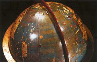
But if you try and
search the Internet using "Piri
Reis map" as keywords, you will surely come across many web sites
dedicated to "mysteries", which allege that this map, dated "Year 919 in Muslim
Calendar" (A.D. 1513 in our calendar), contains a precise representation of
the coasts of Antarctica, a continent unknown at that time. The same happens
for other famous maps, such as the one drawn by Orontius
Finaeus in 1531 and the one by Philippe
Buache, , dated 1739. According to Charles Hapgood, author of "Maps of
the Ancient Sea Kings: Evidence of Advanced Civilization in the Ice Age",
those map contain a precise representation of Antarctica as it was before
last ice age. The same idea was advanced by Von Daniken in "Chariots of Gods"
and by Flavio Barberio in "Una
civiltà sotto ghiaccio",
but the most famous book among the ones which made this theory so popular,
is Graham Hancock's archeological fiction "Fingerprints of the Gods".
According to many
mystery enthusiasts, these maps were either based on ancient representations,
perhaps dating as far back as the mythical Atlantis, or were drawn from pictures
taken from the sky, by satellites, aircrafts or spaceships. That because the
knowledge available as of 16th century cannot explain such stunning correspondence
with reality.
Both Hapgood and
Hancock claim that the representation of the Antarctic continent is incredibly
precise. And since it clearly indicates rivers, lakes and mountains, this
ancient cartographic model could date as back as 15,000 years ago. They also
suggest that the map was drawn basing on surveys, which must have been taken
from a satellite in a geostationary orbit over... Egypt. The usual, recurring
Egypt of mysteries.
In this page I will
try a much simpler explaination.
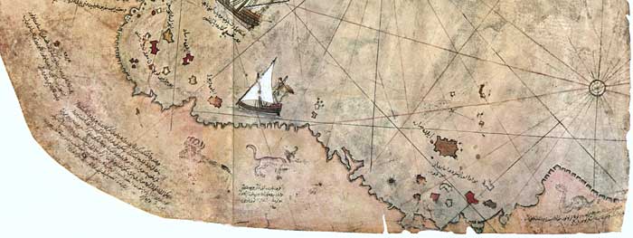
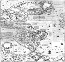
What
is known today as the map of the Turkish admiral Piri Reis is actually just
a fragment of the original, much larger map, which represented the whole
known
world. This surviving portion represents Atlantic Ocean, western coasts of
Europe and Africa, and eastern coasts of America. It is dated "Muslim
Year 919", which corresponds to our A.D. 1513 (but the map was presented
to the Sultan in 1517). According to its author, the map was compiled
from "twenty
older charts and eight planispheres". It is very likely that Reis also examined
the journey accounts written by early explorers of New World, expecially
Portuguese,
as they are often mentioned within notes on the map. The notes
have been transcribed by Turkish scholar Bay Hasan Fehmi and published by
Yusuf Akcura, President of the Society for Turkish Historical Research, in
1935
in his
work “Piri
Reis Haritasi”,
and then re-published by Ayse Afetinan in "The
oldest map of America" in 1954. It is worth nothing that, although
this and other maps abound with clear and perfectly readable text and captions,
the authors who present them as proof of their extravagant theses quote nothing
but few lines. The only region of South America to look sufficiently detailed
on the map is the coast of Brazil, although River of Amazones is drawn twice,
in different locations. Other areas such as Caribbean islands, though already
explored at that time, are roughly charted, with evident errors in both position
and orientation.
Piri Reis himself states, in
a note,
that he consulted the charts of Cristopher Columbus. The
peculiar (and wrong) configuration of the Caribbean area in his map seem
to confirm that statement. That region of the American continent is indeed
improperly represented: it features a large island arranged north-south,
which cannot easily be identified with Cuba, not even by rotating the whole
map counterclockwise by 90 degrees.

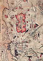
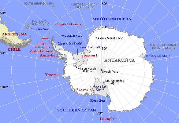
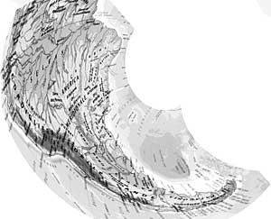
But what mystery
lovers are most enthusiastic about is the bottom edge of the map, which is
said to represent Antarctica. Some claim that Land of Queen Maud and other
features of Antarctica are clearly recognizable on the map, even though that
continent was not explored but many centuries later. Unfortunatley these people,
including Hancock, claim the above hypothesis without making any cartographic
comparison or first-hand check: they just accept Charles Hapgood's statements
as true. Hancock in particular does not mention any book about history of
cartography within the notes of the first two chapters of his book "Fingerprints
of the Gods" (the very chapters about geographic charts). He just quotes Hapgood's
work, thus clearly showing that he didn't even make an attempt to learn on
the subject.
.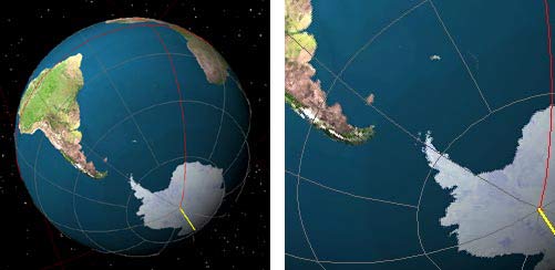
. Moreover, if the
map of Piri Reis is so accurate and if the land depicted at the bottom edge
of it is really Anctartica, one may ask why none of those authors explains
what has become of the missing 1200 miles of coast from Brazil to Tierra del
Fuego (the whole length of Argentina), and why this odd Antarctica protrudes
from Brazil instead of laying 2500 miles south of it.
One just needs to
examine that part of the map carefully to realize, even without being an expert
cartographer, that it represents nothing more than the extremity of the south-american
continent, an approximate representation made possibile by means available
at that time. The drawing is deformed, slanted to the right, possibly to conform
to the peculiar shape of the piece of parchment. It is also worth mentioning
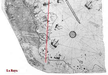
that cartographic maps were used as political tools as well. Placing some
land on either side of the meridian dubbed "la Raya" which was agreed upon
as a demarcation between Spanish and Portuguese zones of influence could
serve as an excuse for the corresponding power to claim rights of possession.
Piri Reis often mentions Portuguese maps in his notes, and of course Portuguese
would have preferred the coast south of Brazil to bend sharply to the right
towards Africa. That would have placed the coast within the 180 degrees assigned
to their jurisdiction by Treaty of Tordesillas in 1494.
We must also not
forget that pratical methods of calculating the longitude were invented only
a century later. Earlier maps thus contained a great degree of approximation,
and different drawing "styles" were employed according to the purpose of the
chart
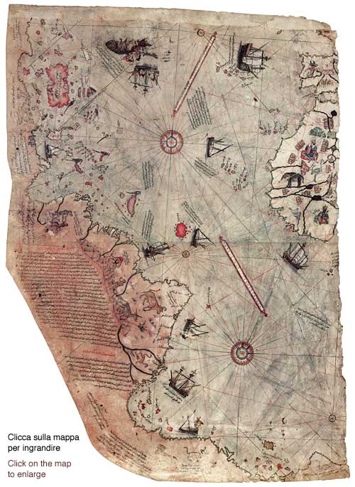
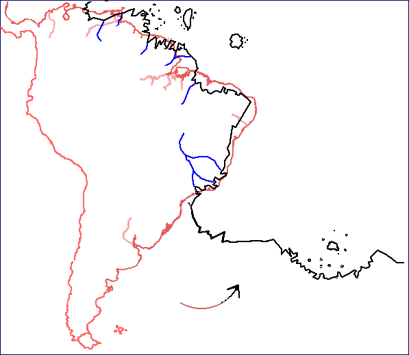
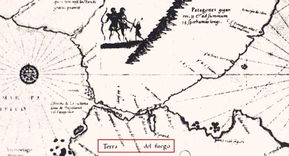
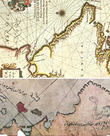
In order to identify
the places depicted on the bottom part of Piri Reis's map, we can try and
rotate a map of South America counterclockwise by 90 degrees. We must keep
in mind, though, that no precise measuring instruments were available at that
time. Thus, cartographers would draw their maps of newly discovered coasts
basing on early journey accounts, which talked generically about capes, islands,
river mouths, gulfs, and so on. Charts would therefore contain pieces of information
and of geographical data not correctly calculated, nor in correct relationship
among each other.
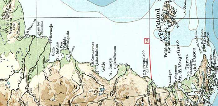
We can nonetheless
recognise, albeit deformed, some features such as Gulf of San Matias and Peninsula
Valdes, while the extremity could be Tierra del Fuego. We could maybe even
identify the mouth of Strait of Magellan, with its peculiar small gulf.. If
we now look carefully at the bottom-right edge, which is supposed to represent
Anctartica, we can see a small picture of a snake. A corresponding note by
Piri Reis reads: "This land is uninhabited. Everything is in ruin (barren?)
and it is said that large snakes are found here. For this reason the Portuguese
infidels did not land on these shores and these are also said to be very hot."
Clearly such a description does not fit Antarctica at all.
 .
.
.
.
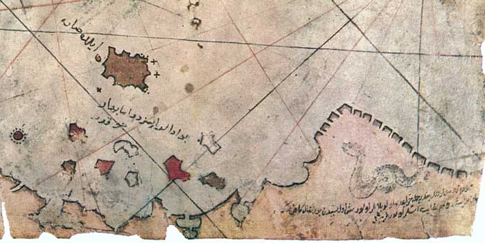
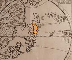
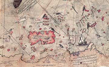
Close to the bottom
of Piri Reis map there is an archipelago featuring a larger island called
"il de Sare". Among those islands is written "Buadalar issizdir, ama bahar
coktur", that is "Those islands are deserted but spring here lasts long".
It could be a primitive representation of Falkland/Malvinas islands (the larger
of which is called Soledad). It may seem quite odd, as the small archipelago
was "officially" discovered in 1592. But a group of islands in the same location
can be seen on the Circolus Antarticus chart by Pedro Reinel, dated 1522 (Istambul,
Topkapi Museum Library). South America in the Circolus Antarticus chart by
Pedro Reinel, 1522 (Istambul, Topkapi Museum Library).
South
America in the Circolus Antarticus cart by Pedro Reinel, 1522 (Istambul,
Topkapi Museum Library)
And a group of islands
off 50th parallel appears in the Martin Waldseemuller's map of 1507 as well.
It is thus possibile, though not officially documented, that some navigator
coasting the south-eastern end of America during the first decade of 1500
actually sighted an archipelago, and reported the sighting back home. Such
an hypothesis is mentioned on some web pages about Falkland Islands' history
(see page
1 and page
2), too. Those pages also suggest the names of Amerigo Vespucci and Binot
Paulmier de Gonneville.
Waldseemuller
cart of 1507, with an enlargement of South America explored by Amerigo Vespucci
as far as 50° parallel
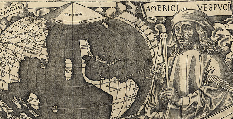
Another
enlargement from the Waldseemuller map of 1507
Waldseemuller map
of 1507, with an enlargement of the portion of South America explored by Amerigo
Vespucci, who reached as far south as 50° parallel Another enlargement from
the Waldseemuller map of 1507 Waldseemuller's map derives from the very accounts
of the journeys made by Vespucci. In this document the newly discovered continent
is for the first time referred to as "America", a name the author chose in
honor of Amerigo Vespucci. This map too could have formed the basis of Piri
Reis' compilation work, as Columbus' charts did.
After Vespucci's
last journey, more and more expeditions were undertaken with the purpose of
opening a new route towards Asia, but no result was obtained until 1520. It
is thus not unreasonable to suppose that other expeditions might have sailed
along the remaining short strecth of coast, up to the strait located at 54th
parallel, even before 1513. The strait was later named after Magellan, who
in 1520 realized it was not a mere gulf but a way between Atlantic and Pacific
oceans. Magellan then succeeded in crossing the strait among many difficulties,
and finally reached Philippines.
At that time, the
land south of the strait was thought to represent the northern edge of that
large continent which, according to tolemaic tradition, must have existed
in the southern emisphere to balance the quantity of emerged lands in the
northern one. Furthermore, many charts and planispheres of that period read
"Terra Australis Incognita" (Unknown Austral Land) on the land south of the
strait of Magellan.
 .
.
.
. .
.
.
.
World
maps by Camocio, LeTestu and Mercator
Mercator,
World Map, 1569 (part.)
The southern end
of Tierra del Fuego - thus named because of the villages' bonfires
Magellan saw while sailing across the strait - is Cape Horn, swept by winds
and stormy, which was circumnavigated only in 1615. That too did not happen
for the sake of knowledge but for mere economical reasons. Indeed, two Dutches,
Cornelius Shouten and Jacob Lemaire, intended to reach Indonesian seas avoiding
all known routes (strait of Magellan, Cape of Good Hope), as Company of Indies
had denied them the permission to follow those routes. They succedeed in their
feat, but once they reached Java they were arrested by Dutch authorities,
which disbelieved their discovery of a new route. Tierra del Fuego was in
fact commonly thought to be a peninsula linked to "Terra Australis".
 . . .
. . .
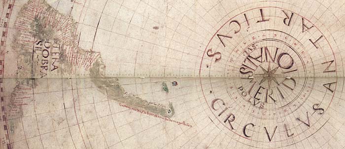
The
map drawn by Jan Jansson after Lemaire circumnavigation of the Tierra del
Fuego.
To the right a detail of the mouth of the Strait of Magellan, compared to
a detail of Piri Reis map.
A
comparison between a close-up of Piri Reis map and a modern map of the Magellan
strait entrance and Tierra del Fuego rotated counterclockwise by 90 degrees.
It could just be
a coincidence, but one cannot but notice the presence, in both charts, of
the two basins forming the mouth of Strait of Magellan, and of another large
bay farther south. Could the mistery of Piri Reis' map be just that? Did Piri
Reis employ the journey accounts of the Portuguese sailors who reached Tierra
del Fuego before Magellan? Magellan set out in 1519 and it looks like he already
knew about some strait or bay as "he saw it, in the Treasury of the King of
Portugal, on a map drawn by Martin de Bohemia" (Martin Behaim), as the journey's
chronicler Antonio Pigafetta tells us. Or, on the contrary, can we speculate
that the lower extremity of the map was added later, after the journey of
1519? We indeed know that the chart of Pedro Reinel, kept in the same Library
of Topkapi, was probably retouched after the discovery of the Strait of Magellan
But the more probable
hypothesis remains that, drawing the extremity of the South American continent,
Piri Reis would
have been based on the more diffuse geographic theories in the first
decades of the ' 500. According to many geographers of the age the
more southern
part of the South America would have been joined to the mythical
Terra Australis Incognita. The map of Lopo Homem (1519) can allow us to reconstruct
the aspect of the complete map of Piri Reis:
In this map, from the famous Atlas Miller, we see that the still unexplored extremity of the
South American continent fold towards east, going to form the mythical austral
continent that, touching the indonesian archipelago, continues without a break until the extremity of Asia.
See also :
THE
OLDEST MAP OF AMERICA by A. Afetinan
Minds in Ablation Part Five: Charting Imaginary Worlds by Sean Mewhinney
Piri Reis and the Hapgood Hypotheses by Paul F. Hoye with Paul Lunde
A Tale Of Two Admirals by Gregory C. McIntosh
Links to web pages containing
rich image archives concerning maps, planispheres and nautical carts:
THE GUIDE TO MAPS AND MAPPING
CARTOGRAPHIC IMAGES
HOME PAGE
JAMES FORD BELL
LIBRARY
MAP HISTORY / History of Cartography
ODDENS Bookmarks
- The Fascinating World of Maps and Mapping
Marco
Capurro, "MAPPE DI CITTA' ed altre mappe antiche diverse"
An italian page about the myth of "Terra
Australis"
Other studies of Diego
Cuoghi in www.diegocuoghi.com
E-MAIL